
Research
Our research
The long-term goals of our research are to advance the understanding of earthquake, volcanic, and Earth surface processes to aid in hazard mitigation and sustainable development.
We seek to quantify how stress perturbations, fluid migration, and subsurface dynamics drive seismic and volcanic activity. We are best known for applying machine learning to produce high-resolution earthquake catalogues, which are especially powerful when paired with advanced statistical methods to reveal otherwise inaccessible features of fault systems and volcanic plumbing.
Our group integrates seismology (dense arrays, ocean-bottom seismometers), geophysical data analysis (catalogue construction, waveform classification), and computation to study hazard processes and to improve early warning and forecasting. Group members move fluidly between data and models, often inventing new methods to answer their questions.
We work on many different tectonic and volcanic systems because we find ourselves drawn, again and again, to the power of high-resolution seismic data: as catalogue completeness improves, pattern recognition becomes easier — until the resolution gets too good, and then the spatiotemporal complexity begins to reveal itself and the interesting challenges begin.
Theme 01
Machine learning applications in geophysics
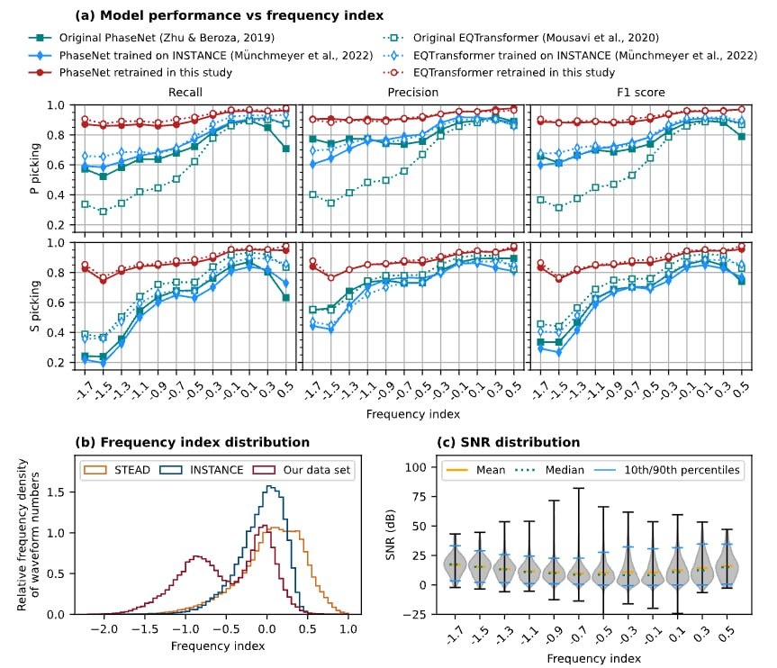
We have applied machine learning to identify eruption precursors, to improve detection of different types of seismic events, and to produce high-resolution earthquake catalogues that map fault structures and constrain earthquake interactions.
Those catalogues have let us characterise foreshock sequences and swarms, including along oceanic transform faults where conventional detection thresholds leave most of the seismicity unseen.
Key publications
- Tan et al. (2021) (opens in a new tab) — Machine-learning-based high-resolution earthquake catalog reveals how complex fault structures were activated during the 2016–2017 central Italy sequence. The Seismic Record
- Liu et al. (2024) (opens in a new tab) — Intersection between tectonic faults and magmatic systems promotes swarms with large-magnitude earthquakes around the Tengchong volcanic field, southeastern Tibetan Plateau. Geology
- Zhong et al. (2024) (opens in a new tab) — Deep-learning-based phase picking for volcano-tectonic and long-period earthquakes. Geophysical Research Letters
- Liu et al. (2025) (opens in a new tab) — Fluids and fault structures underlying the complex foreshock sequence of the 2021 Mw 6.1 Yangbi earthquake. Earth and Planetary Science Letters
- Liu et al. (2025) (opens in a new tab) — Evaluating the performance of machine-learning-based phase pickers when applied to ocean bottom seismic data: Blanco oceanic transform fault as a case study. Geophysical Journal International
- Liu et al. (2026) (opens in a new tab) — Large earthquakes along the Mendocino oceanic transform fault hardly have any foreshocks. Geophysical Research Letters
 — open the full-size figure in a new tab
Theme 02
Fault response to stress changes
We recognised that external stress perturbations can modulate fault slip behaviour and earthquake nucleation. In both systematic surveys and isolated case studies, we have demonstrated how tidal stress affects earthquake rates and frequency–magnitude distributions, constraining frictional properties.
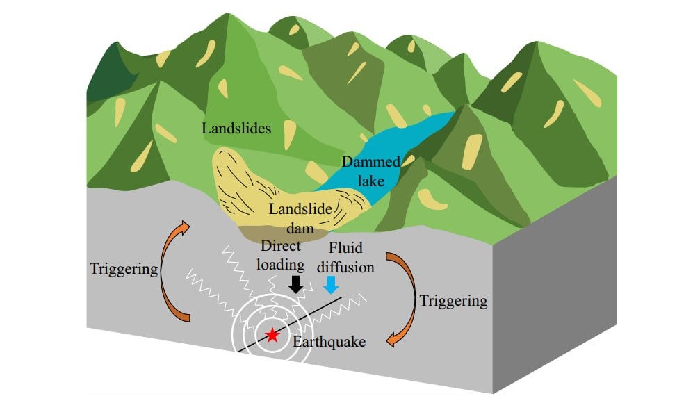
We have also identified how dynamic triggering by teleseismic waves, reservoir-induced seismicity, and landslide-dammed lakes reveal the state of stress on faults.
Key publications
- Tan et al. (2018) (opens in a new tab) — Tidal triggering of microearthquakes over an eruption cycle at 9°50′N East Pacific Rise. Geophysical Research Letters
- Tan et al. (2019) (opens in a new tab) — Axial Seamount: Periodic tidal loading reveals stress dependence of the earthquake size distribution (b value). Earth and Planetary Science Letters
- Scholz et al. (2019) (opens in a new tab) — The mechanism of tidal triggering of earthquakes at mid-ocean ridges. Nature Communications
- Barkat et al. (2024) (opens in a new tab) — Permeability and seismicity rate changes at an inflating submarine volcano caused by dynamic stresses. Earth and Planetary Science Letters
- Zhang et al. (2024) (opens in a new tab) — Landslide hazard cascades can trigger earthquakes. Nature Communications
- Barkat et al. (2024) (opens in a new tab) — Deciphering the interplay between reservoir loading and dynamic stresses at the Pertusillo Reservoir. Seismological Research Letters
 — open the full-size figure in a new tab
Theme 03
Dynamics of volcanic systems
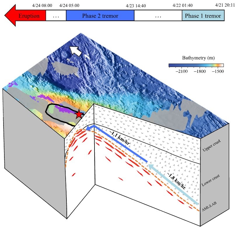
We are interested in the structural dynamics and hazard assessment of submarine and subaerial volcanic systems. Using ocean-bottom seismometer (OBS) data, we analyse microearthquakes, mixed-frequency earthquakes, tremors, and seismo-acoustic events to characterise magmatic processes and seismic velocity changes.
With machine learning platforms, we develop models for detecting long-period and volcano-tectonic earthquakes, and we continue to push the limits of what OBS networks can resolve about an active volcanic system.
Key publications
- Tan et al. (2016) (opens in a new tab) — Dynamics of a seafloor spreading episode at the East Pacific Rise. Nature
- Wilcock et al. (2016) (opens in a new tab) — Seismic constraints on caldera dynamics from the 2015 Axial Seamount eruption. Science
- Lee et al. (2024) (opens in a new tab) — Relative seismic velocity variations at Axial Seamount observed with ambient seismic noise capture transition point in volcanic inflation. Geophysical Research Letters
- Wang et al. (2025) (opens in a new tab) — Source mechanism of impulsive seafloor events that track submarine lava flows. Science Advances
- Zhu et al. (2026) (opens in a new tab) — Migrating tremors indicate the activation of distributed melt bodies days before the 2015 Axial Seamount eruption. Geology
 — open the full-size figure in a new tab
Theme 04
Low-frequency and long-period earthquakes
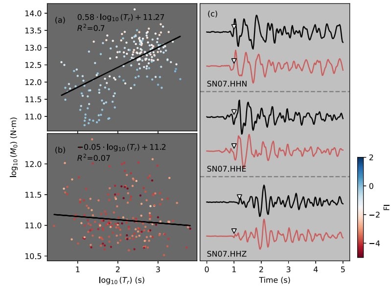
We are intrigued by the spatiotemporal clustering and scaling properties of low-frequency earthquakes (LFEs), and we apply these insights to large-scale studies of slow-slip events and fault slip velocities.
We investigate LFE source processes to track fluid and magma movement and to support eruption forecasting. We like to bring a statistical seismology perspective to the table, to understand the relative importance of tectonic and volcanic loading in shaping the fault systems we observe today.
Key publications
- Tan et al. (2020) (opens in a new tab) — Connecting a broad spectrum of transient slip on the San Andreas fault. Science Advances
- Song et al. (2023) (opens in a new tab) — Deep long-period earthquakes at Akutan Volcano from 2005–2017 better track magma influxes than volcano-tectonic earthquakes. Geophysical Research Letters
- Song et al. (2025) (opens in a new tab) — Characteristics of deep long-period earthquakes at Alaska Volcanoes from 2005 to 2017. Journal of Geophysical Research: Solid Earth
- Song et al. (2026) (opens in a new tab) — Long-period microseismicity reveals cryptic earthquake-triggered fluid activity can facilitate caldera eruptions. Nature Communications
 — open the full-size figure in a new tab
Theme 05
Earth surface processes and hazard cascades
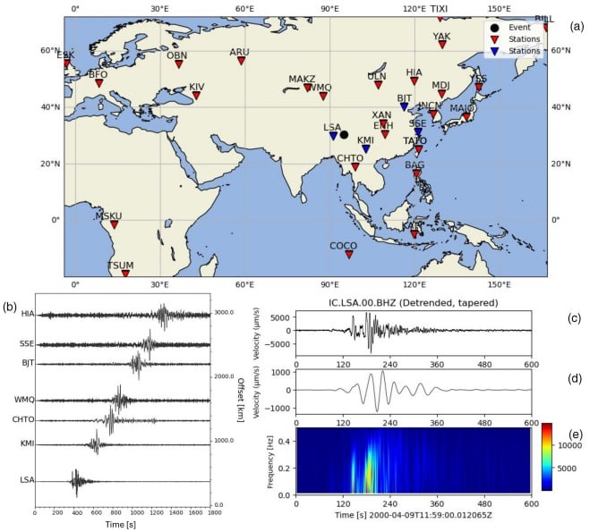
A major challenge in geohazard science is the inability to directly monitor and quantify rapid mass movements and their cascading impacts. We use seismic methods to quantify the dynamics of large landslides, dam breaches, and outburst floods.
In recent work we discovered that landslide hazard cascades can trigger earthquakes, revealing previously unrecognised linkages between surface and subsurface hazards. Our long-term goal is to increase the information content of every seismic record, to reveal the full chain of geophysical events and improve multi-hazard early warning.
Key publications
- Zhang et al. (2024) (opens in a new tab) — Seismic monitoring and geomorphic impacts of the catastrophic 2018 Baige landslide hazard cascades in the Tibetan plateau. Journal of Geophysical Research: Earth Surface
- Zhang et al. (2024) (opens in a new tab) — Landslide hazard cascades can trigger earthquakes. Nature Communications
- Ho et al. (2025) (opens in a new tab) — Analysing dynamics of the 2000 Yigong landslide in the Tibetan plateau using seismic observations. Landslides
- Zhang et al. — Citizen seismology enables low-cost early detection of catastrophic mass movements. PNAS (under review)
 — open the full-size figure in a new tab
A complete, numbered list of the group's work — with peer reviews where they are public — is on the publications page.